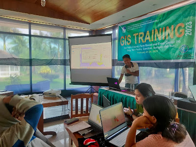
CENRO Cantilan personnel undergo GIS training
CANTILAN, Surigao del Sur -- The Department of Environment and Natural Resources (DENR) - CENRO Cantilan headed by Gay P. Resullar successfully conducted a four -day training on Geographic Information System (GIS) using ArcGIS recently held at San Pedro Country Farm Resort and Event Center, Inc., Brgy. San Pedro, Cantilan, Surigao del Sur.
The said training capacitated the Community ENRO Cantilan personnel on
the fundamental concepts of ArcGIS and its applications.
The said activity enhanced the capabilities of the participants on basic map
creations and come up with generated maps as outputs and to orient the trainees
on the functions of different ArcGIS features.
The independent use of ArcGIS through the knowledge application of basic ArcGIS
concepts, principles, and operations; and other ArcGIS applications especially
those related to public administration and governance were also introduced.
During the opening program, Resullar emphasized in his message that the
conducted GIS training will address the needs of the personnel to be equipped
with the necessary skills and expertise.
The knowledge they gained during the activities would equip them to
perform related tasks using ArcGIS application in planning, policy formulation,
monitoring and evaluation, and formulation of spatial strategies in relation to
Plans/Programs and activities of DENR. (NGPB/CENRO-Cantilan/PIA-Surigao del
Sur)

