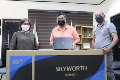
𝐃𝐎𝐒𝐓 u𝐩𝐠𝐫𝐚𝐝𝐞𝐬 𝐈𝐂𝐓 𝐨𝐟 𝐋𝐆𝐔 𝐉𝐚𝐛𝐨𝐧𝐠𝐚’𝐬 𝐃𝐑𝐑𝐌 f𝐚𝐜𝐢𝐥𝐢𝐭𝐲
BUTUAN CITY -- In the pursuit of attaining disaster resiliency for the communities in Caraga, the Provincial Science and Technology Center (PSTC) of Agusan del Norte successfully turned over one unit of a 65-inch smart television set; and two units of hi-end laptop computers to the local government unit (LGU) of Jabonga, Agusan del Norte for the purpose of upgrading its disaster risk reduction and management (DRRM) facility.
These shall serve as an advanced repository for DRRM-related data at the Municipal Disaster Risk Reduction and Management Office. With larger storage capacity and high-speed processors, these equipment will be utilized for faster data generation from various systems running for the municipality’s disaster prevention and mitigation, particularly from the Local Government Unit Information Dissemination System (LGUIDS); Flood Event Visualizations and Damage Estimations (Flood EViDENs); and Light Detection and Ranging (LiDAR).
With the upgraded ICT, the LGU can now easily access online reports and maps, early warning systems, including real-time updates from weather and earthquake monitoring stations, and advisories from the Regional DRRM Council. These are necessary for the LGU’s proper assessment, decision-making and identification of appropriate strategies for disaster prevention and mitigation. It will further enable the emergency operations center to speed up and strengthen its information dissemination to ensure that the members of the community are fully aware of disasters that may occur, along with the necessary precautionary measures that they need to follow.
Jabonga is a lakeshore municipality, with the majority of its barangays surrounding the country’s fourth largest lake, the Mainit Lake which receives inflows from 28 major and minor tributaries and discharges only to one outlet, the Kalinawan River that passes thru the municipality. With the occurrence of weather disturbances, the river often overflows resulting in frequent flooding in the area.
The improvement of the DRRM ICT will aid the municipality’s enhancement of its existing disaster risk management strategies geared towards attaining a safer, adaptive, and disaster-resilient community towards sustainable development. (DOST Agusan del Norte/PIA Agusan del Norte)

